On June 21, India launched the Polar Satellite Launch Vehicle (PSLV) rocket from the Satish Dhawan Space Centre with 20 satellites aboard, including one made by the Canadian firm GHGSat that measures greenhouse gas emissions from industrial sites, using algorithms to interpret, store and manage the data. Photo credit: GHGSat
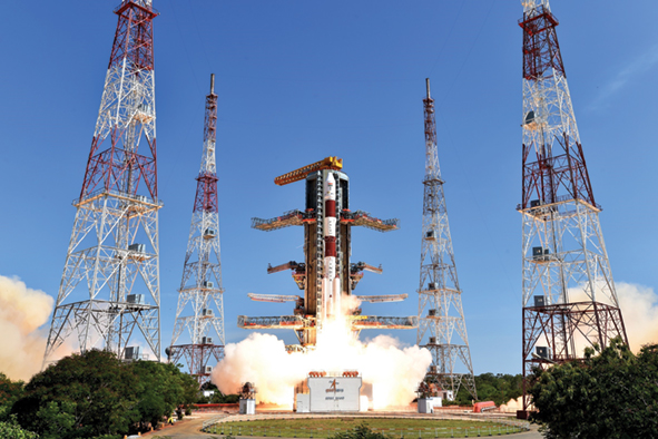
On the first day of summer — June 21 — the government of India launched a 44-metre-tall Polar Satellite Launch Vehicle (PSLV) rocket from the Satish Dhawan Space Centre, located on Sriharikota Island on the country’s east coast. The rocket carried satellites from nations like Germany, Indonesia and the United States as well as a Canadian demonstration satellite named CLAIRE. Designed and built by GHGSat, a Montreal-based firm that is developing satellite technology, CLAIRE remotely senses and measures greenhouse gas (GHG) and air quality gas emissions from industrial sites.
Among the many Canadian supporters, backers and customers of the GHGSat launch is Canada’s Oil Sands Innovation Alliance (COSIA), a group of 13 oil sands producers that was formed in March 2012 to exchange and collaborate on the development of environmental technologies and innovations — sharing royalty-free use rights to proprietary technology — as well as develop and share best practices, says CEO Dan Wicklum, a former biologist who has headed COSIA since its creation four years ago.
Back in 2012, the consortium identified four key environmental improvement areas. These included land restoration, tailings ponds, improved water management and a reduction in surface mining and in-situ emissions of carbon dioxide, methane, nitrous oxide and ozone — all chemicals that have been identified as significant drivers of climate change.
According to Environment Canada 2015 statistics, Alberta’s oil sands operations accounted for 8.5 percent of Canada’s total GHG emissions. (Total oil and gas production across Canada accounts for even more — 26 percent, according to Environment Canada — of total GHGs.) Environment Canada further estimates that, by 2030, the oil sands’ share of the country’s total GHG emissions will rise to 14 percent due to a projected increase of 124 percent, or 64 megatonnes, between 2010 and 2030. (The projection doesn’t take into account planned measures to cut GHG emissions.) Such predictions present a major challenge in light of this past April’s signing by Canada of the Paris Agreement on climate change, which was hammered out at the 2015 United Nations Climate Change Conference, or COP 21. Prime Minister Justin Trudeau pledged to harness the power of renewable energy to reduce GHG emissions. Trudeau also committed to a reduction of GHG emissions by 30 percent from 2005 levels by 2030, on par with a goal set by the previous Conservative government. Not part of the Paris Agreement, but notable nonetheless, was Alberta’s NDP government’s announcement of a cap on emissions that features halving methane emissions within a decade, in addition to a carbon tax starting in 2017.
Wicklum says that such objectives are not at odds with the progress being made in the oil sands industry, which continues to prioritize sustainability innovations despite the downturn in crude oil prices — a dramatic 75 percent drop resulting in an estimated 37,000 job losses between June 2014 and February of this year. With about 240 sustainability projects on the go, carrying a price tag of about $480 million, “the companies are investing significantly,” Wicklum says.
One of the game changers, says Wicklum, is GHGSat. Currently, oil sands GHG emissions like CO2 and methane are estimated using a dinghy that floats across tailings ponds carrying an on-board gas analyzer. Pioneered by the United States Environmental Protection Agency (EPA) and used by industries around the world, this method has a significant margin of error, with the EPA reporting an accuracy of plus or minus 100 percent. The GHGSat will take emission measurements to the next level, providing more accurate data that will lead to better decision-making and enhance emission management, says Wicklum. “Going from a traditional type of measurement to a satellite-based one is a remarkable change — the better you measure it, the better you manage it.”
The GHGSat satellite’s field of view takes in about 12 kilometres by 12 kilometres of the Earth’s surface, says GHGSat president Stéphane Germain. Its orbit is determined by the main payload from the June 21 launch — an Indian Earth observation and land mapping satellite called Cartosat-2C that operates in a sun-synchronous orbit 500 kilometres above the planet. This means that the satellite, when it revisits any particular point on the Earth’s surface during its orbit back and forth between the North to South pole, consistently arrives at the same local time of day for that point on Earth, says Germain.
The GHGSat satellite specifically looks at and records the short wave infrared wavelengths that are characteristic of CO2 and methane. Such atmospheric gases have what Germain refers to as a “spectral fingerprint,” the distinct frequencies of light that are characteristic of the molecules and electron transition in those gases. “We’re looking at these very specific and exotic short-wave infrared wavelengths that are characteristic of CO2 and methane.”
Tuned to these frequencies, the satellite effectively takes a picture of the surface of the Earth over a given site of interest. The captured data forms what is known as a hyperspectral cube, with two dimensions providing a picture of the Earth’s surface, much like a Google Maps image, and a third dimension recording the spectral information. The satellite determines both the presence and abundance of a gas that’s in the field of view.

The red circle in this photo identifies the injection mechanism holding the GHGSat satellite, one of about 20 satellites being carried into space by the Indian rocket. Once it reaches an altitude of 500 kilometres, the injection mechanism acts like a jack in the box. The top pops open the top and the satellite has a spring that then pushes it out into space. Photo credit: GHGSat
Post-processing software collects all the data that comes off the satellite and does radiometric calibrations, Germain says. The result is a measure of how much CO2 and methane are within each 50-metre by 50-metre pixel in a 12 kilometre by 12 kilometre field of view on the Earth’s surface. By analyzing this data, the satellite’s operators can determine an emission rate from the source, says Germain. Dispersion modelling considering wind and changes in topography must also be taken into account when assessing emissions. The satellite provides the dispersion pattern of the gas, and an “inverse dispersion” model is then iterated with assumed source emission rates and assumed wind parameters until there is a convergence. “That’s how we get the emission rate at the source. It’s a lot of post-processing,” says Germain.
Ultimately COSIA “wants to get the best possible measurements that they can and then report them publicly,” Germain says. “They know they’ve got a problem and they’re trying to get the best possible measurement of their emissions. If you can get a better measurement and an understanding of what your actual emissions are then you can start working with different control techniques or different operating regimes that will allow you to reduce those emissions.”
COSIA is not the only customer of GHGSat, which is capable of providing data for up to 1,000 customers, says Germain. Besides COSIA, other clients include Manitoba Hydro and Hydro-Québec, whose hydroelectric reservoirs produce CO2 and methane when vast tracts of vegetation flood from damming. Germain adds that GHGSat measurements will cost a fraction of the price of conventional emission analysis techniques.
In addition to the monitoring provided by GHGSat, COSIA is championing other projects designed to mitigate the production of CO2. One of these is the Algal Carbon Conversion Project. This carbon-capture initiative uses algae grown on emissions from natural gas burners used to produce the steam that’s injected underground during in-situ bitumen extraction. The algae consume CO2, nitrogen and sulphur in the flue gas and can be converted into value-added products like bio-oil and fertilizer. The initial engineering phase of the algal carbon conversion demonstration project has been completed, however, “the project is currently being restructured due to evolving business needs of the partners,” says Julie Woo, spokesperson for Canadian Natural Resources (Canadian Natural), an oil and natural gas exploration, development and production company based in Calgary. Canadian Natural is one of several partners on the project, which includes the National Research Council and Ontario’s Pond Biofuels. “Important research and development in this area is progressing well,” Woo adds.
Initiatives like the algae project are an example of COSIA’s embrace of collaboration, not only with members but also post-secondary institutions, government agencies and “anyone in the world who has a good idea,” says Wicklum. COSIA has more than 40 associate members ranging from numerous universities, including Alberta, Calgary, Lethbridge and Waterloo as well as corporations like General Electric, he says. About two years ago, COSIA also created the Environmental Technology Assessment Portal, or ETAP, which allows anyone — student, professor, entrepreneur or government affiliate — to submit an idea for member companies to analyze. “They can get ideas in front of the companies quickly.”
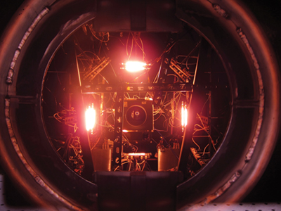
GHGSat’s satellite underwent a series of environmental tests before being launched into space on the Polar Satellite Launch Vehicle rocket. Here the satellite (the small, rectangle box in the middle with the circular aperture for the optical instrument) sits in a thermal vacuum chamber where it is heated to simulate conditions it will encounter in orbit. Photo credit: GHGSat
Collaboration from outside the alliance is beginning to bear fruit. Exactly a year ago, COSIA launched the $20 million NRG COSIA Carbon XPRIZE, a global competition calling for cutting-edge technologies to convert CO2 into high net-value products. To date, 47 entries from seven countries have submitted proposals to the contest, which is a four-and-a-half-year endeavour that will test new technologies at either a coal power plant or natural gas facility. The XPRIZE is intended to accelerate the development and use of carbon capture technologies that will ultimately help to address climate change. Twelve Canadian teams out of a total of 38 that hail from China, India, Finland, Switzerland, Scotland and the US are competing for the prize money. Among the Canadian contenders is Ted Sargent of the University of Toronto Faculty of Applied Science & Engineering, whose areas of research include using renewable electricity from solar or wind generation to convert CO2 into carbon monoxide, a building block for chemical fuels like ethanol and methanol. Up to 15 semi-finalists will be announced Oct. 15.
Water reduction and conservation by the oil sands industry is also being targeted by COSIA members, says Wicklum. For example, Suncor Energy, which is Canada’s largest oil sands producer, is constructing the $165 million Water Technology Development Centre that involves COSIA members as well as Husky Energy. Suncor is also at the forefront of technologies like steam-assisted gravity drainage (SAGD). Not only is SAGD able to reach the 80 percent of deposits that are too deep to be surface mined, it is able to recycle more than 90 percent of the water used to produce steam.
Wicklum also points to the Enhanced Solvent Extraction Incorporating Electromagnetic Heating (ESEIEH) project, which is in its second year of testing at Suncor’s Dover oil sands project in northern Alberta. The technology uses low-frequency radio energy created by a surface generator to melt bitumen. “This and other technologies like it are potentially breakthrough technologies.”
Such ongoing technological innovation by COSIA presents a “great economic opportunity for individuals, organizations and companies in technology as it relates to combating climate change as well as a great opportunity for Canada to contribute to global solutions,” says Wicklum, adding that government funding for oil sands innovative technologies is a sound economic and environmental investment for Canada.
Despite the varied innovations being advanced by the oil sands industry, some take the position that it is too little, too late. Keith Stewart, Greenpeace Canada’s climate and energy spokesperson, says that the country should focus on attaining a “zero carbon economy” in accordance with the Paris Agreement. “We have to be looking at how we get off fossil fuels, so we would like to see research and development dollars being invested in zero carbon technologies rather than in reductions,” Stewart says. He also questions the oil sands’ ability to reduce GHG emissions, largely in part because companies are being forced to move to tougher reserves requiring more in-situ extraction. And while COSIA currently tallies 11 tailings pond mitigation projects on its website, Stewart says that little has actually been done. “They say, ‘we’re going to clean these up’ and they never do.”
Stewart insists that phase-out planning of the oil sands should begin now: stopping expansion, cleaning up existing operations and planning for a transition to renewables like solar, wind and geothermal energy. “These are the sorts of energy alternatives that could create jobs in Alberta.”